'Signifigant' site faces destruction
A large site on the Tara motorway route is unlikely to be saved, despite it having been declared a national monument. By Emma Browne
The national monument found at Lismullin on the Tara motorway route earlier this year proves that the Hill of Tara is part of a wider royal landscape, something the National Roads Authority (NRA) and Meath County Council (MCC) disputed in the past.
Opponents of the Tara M3 motorway argued from the outset that the road would destroy significant archaeological sites in the landscape of Tara. They argued that the Hill of Tara, near which the road will travel, was part of a larger royal landscape, and that there were many significant archaeological sites around it yet to be identified. But the NRA and Meath County Council did not accept the view that Tara was part of a wider landscape, and maintained that, were such archaeological sites located in the area, their own tests would help identify them.
But a site recently discovered directly under the path of the road did not show up in the NRA's initial testing. The discovery has vindicated the opponents' claim that the Hill of Tara is part of a wider landscape, as similar sites have only ever been found in royal sites around Ireland.
Conor Newman, an expert on Tara, says, “The site proves without a shadow of a doubt that the Tara complex extends into the surrounding landscape.” He also says the site is of “major signifigance”.
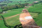
The site has been called Lismullin, and features a henge dating from the late-Neolithic and early-Bronze Age, 500 to 1800 BC. It was most likely used for rituals and is the size of three football pitches. The site is of major significance as the “only parallels to it can be found on royal sites around Ireland”, according to archaeologist and Tara expert Joe Fenwick (see panel, opposite page).
The site was discovered in early-February 2007 and in early-April, it was declared a national monument. On 1 May, Minster for the Environment Dick Roche announced that a national monument had been found during excavations for the M3 motorway.
Under the National Monuments Act 2004, Dick Roche is now deliberating on whether to re-route the road and preserve this site in situ, or to give directions to destroy it. It seems unlikely that the government will now re-route the road when they previosly failed to do so despite huge opposition, a legal challenge and an international campaign against the road. Even when the NRA was warned by its own consultants that the road would travel through an archaeologically-sensitive area, the route was not altered.
The discovery of such a significant and large site was expected by archaeologists who had studied Tara, but they are not surprised that it did not turn up in the testing phases. Conor Newman and Joe Fenwick had both warned the NRA that the tests it carried out to identify archaeological sites along the route were inadequate and would not yield accurate results.
The NRA used a geophysical survey in the first phase – a common method. However, it did not survey the whole road area, instead just concentrating on portions. The geophysical survey, done by GSB Prospection and reported in the year 2000, identified unequivocal or suspected archaeologically-significant geophysical anomalies in 26 of the 30 areas surveyed. Although the survey only revealed little bits of a larger jigsaw, it did show that there was a high number of potential archaeological sites in and around the motorway route.
Conor Newman says that “with such results appearing at regular intervals along this route, [it is a wonder] why the whole route was not surveyed”
It also revealed the sheer scale of the Tara complex as an archaeological site. The area surveyed covered a total of 26 hectares – equivalent in area to about 40 international standard football pitches. So even at a conservative estimate, if one-quarter of the 26 hectares was fully excavated, this still amounts in area to approximately 10 international standard football pitches.
The second process carried out was trench testing, which involves digging trenches and checking what is in them along 60km of the route. However, the NRA conducted this randomly, and not specifically on the sites that had been identified in the geophysical survey.
The NRA said in relation to the testing methods they employed, “No one archaeological assessment technique can identify all archaeological remains hidden below topsoil. It is widely acknowledged throughout Europe that test trenching is the most successful methodology for identifying such sites. The combination of extensive testing, complemented by extensive geophysical survey, is acknowledged as archaeological best practice.”
Joe Fenwick argues that given the sensitivty of the landscape more thorough testing should have been done.
Although the NRA maintains that the current route was the best preferred route, even when taking into account the archaeological sensitivity of the area consultants it employed over the years disagreed.
As far back as 1999, the NRA received advice from consultants VJ Keeley Ltd, saying: “No mitigation would remove the effects of this route on the Hill of Tara or on its outlying monuments. It would have extremely severe implications from an archaeological perspective.”
Margaret Gowen Ltd again warned a couple of years later, “The monuments around Tara cannot be viewed in isolation, or as individual sites, but must be seen in the context of an intact archaeological landscape, which should not under any circumstances be disturbed, in terms of visual or direct impact on the monuments themselves.”
It is unlikely that Dick Roche will re-route the road at this stage, but campaigners believe this is the last chance to save Tara's heritage.